| |
Walks Around Kerry in Powys and Shropshire |
The Forest Country House is fortunate to be located close to some of the best walking in The Marches close to the Welsh and English borders of Powys and Shropshire, Mid Wales. These are the forgotten lands, at the back of beyond. Rural unspoilt, sparsely populated and eternally peaceful, they await discovery. Overshadowed by Snowdonia to the north and the Brecon Beacons to the south, Mid Wales is a 'green desert'. The Marches is a tranquil borderland fought over for centuries with a unique charm of its own. A useful list is Walking Newtown.
There are many walks which can be enjoyed in the area and here are a small selection of the most well known close to our self catering accommodation. Details and maps are available in the cottages and at our bed and breakfast and we can often give advice although we can't promise to have walked them all.
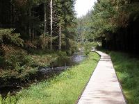
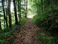 |  | Gilfach Woods - At The Forest The closest walk is right on our door step and can be walked in about an hour. It follows a public path from our accommodation, over Pennaron Hill and down into Kerry or back onto our lane. It is an easy walk pasta natural pond with great views over the hills and the Kerry Ridgeway. |
|
|
| Kerry Ridgeway The Kerry Ridgeway is a gentle 15 mile route through the hills of the central Welsh Marches, walking through history from the Stone Age, via the Bronze and Iron Ages, to a Norman motte and bailey high above Bishop's Castle. The Kerry Ridgeway never dips below 1,000 ft above sea level, resulting in remarkable views in all directions. The ancient highway forges a track through heather moors, woodlands and heaths. | | 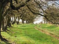 |
|
|
 | | Llanidloes area There are over thirty separate circular and linear routes around the town which are clearly way-marked and signposted. They link Llanidloes with the pretty villages of Llangurig, Llandinam and Trefeglwys and range from just a few miles to a good day's walk. The national trails of Glyndwr's Way and the Severn Way also pass through Llanidloes. There are also walks around Llyn Clywedog and through Hafren Forest. The Sarn Sabrina and Semi-Sabrina Walks take place in May every year and offer you the chance to walk with Sabrina, the spirit of the River Severn up to the source of the Severn and around the Llyn Clywedog. |
|
|
| Glyndwrs Way Glyndwr's Way is another National Trail providing a superb walking experience. Its name derives from the 15th century folk hero Owain Glyndwr who won battles close to the route and held a Welsh parliament in Machynelleth. Glyndwrs Way begins in Knighton, goes through the Radnorshire Hills to Abbeycwmhir, north towards Llanidoes. up to the highest point near Foel Fadian then down to Machynelleth. It touches Lake Vyrnwy before wending its way towards the finish beside the Montgomery Canal in Welshpool | |  |
|
|
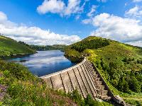
 | | Hafren Forest Hafren Forest takes its name from Afon Hafren (River Severn) which rises in a deep, blanket-peat bog, 800m outside its boundary, high above, on the slopes of Pumlumon. Almost immediately it begins its long journey to the Bristol Channel, passing first through woodlands of pine and spruce. It is possible to walk to Plynlimon, the Source of the Severn from Hafren Forest. The Severn Way, Britain's longest riverside walk, begins at the Source. The attractive nearby market town of Llanidloes acts as a base for Hafren Forest, Llyn Clywedog and many other visitor attractions. |
|
|
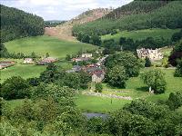
| Offas Dyke The dyke, now designated as the Offa's Dyke Path National Trail, makes a dramatic crossing of Wales from south to north. It follows loosely the line of King Offa of Mercia’s original ditch and, in doing so, also follows loosely the line of the official border between the England and Wales. Offa's Dyke is one of the most remarkable structures in Britain. Offa's intention was to provide Mercia with a ill-defined boundary from Prestatyn to Chepstow, a distance of 240 kilometres. Natural barriers were utilized where that was practicable; where it was not, an earth embankment was built which in places still stands to a height of two and a half meters and which is, with its ditch, up to twenty meters width. | | 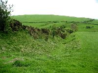 |
|
|
 | | Abbey Cwn Hir Abbeycwmhir is a village situated in amongst the Cambrian mountains in the old county of Radnorshire, steeped in history and natural beauty. A 10.5km walk starts from the village pub, strikes north along forest paths and follows back in the company of Glyndwrs Way to return down forest tracks to the old cistercian abbey ruins. |
|
|
| Stiperstones and Snailbeach Lead Mine The Stiperstones is a distinctive hill in the county of Shropshire, England. It is a quartzite ridge formed some 480 million years ago and is the second-highest hill in the county. Stiperstones' 8-kilometre (5 mi) summit ridge is crowned by several rugged, jagged outcrops of rock silhouetted against the sky.
Part of the walk can include the Snailbeach mine where you can explore the old lead mining buildings recently restored. The mines in this area were once the most productive in Europe. Here at Snailbeach you can follow a self-guided trail around the site and a small information centre is open on Sundays. | | 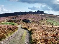 |
|
|
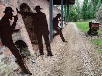 | | Llanymynech Lime Kiln - The Hoffman Hike Llanymynech The Hoffman Hike derives its name from the Hoffman Kiln, one of only three remaining 20th century lime burning kilns in Britain. The kiln, chimney and the distinctive Llanymynech Hill provide the backdrop to some wonderful landscape views, industrial heritage and wildlife habitats
Short circular walks (30 mins - 2 hrs) take you past impressive lime kilns, through woodland, along canals and disused railways, and across grazed pasture with views of Llanymynech Rocks, a Shropshire Wildlife Trust and Montgomery Wildlife Trust nature reserve. There are interpretation panels and specially commissioned sculptures along the way. |
|
|
| Montgomery Walking Festival Montgomery Walking Festival
Historic Landscapes
Friday 6th - Sunday 8th October 2017
- Walk the beautiful panoramic Marches countryside
- Enjoy small, friendly, historic Montgomery
- Experience rich Welsh and English cultural heritage
see website for information | | 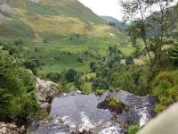 |
|
|
|
|
|